


GREEN BAY, WI- Residents across northeast Wisconsin are urged to stay weather aware today as multiple rounds of severe thunderstorms are expected to impact the region, according to the National Weather Service (NWS) in Green Bay.
Storms are anticipated throughout the day and into the overnight hours, bringing the potential for all types of severe weather, including tornadoes, large hail, damaging winds, and localized flooding.
Mid-Afternoon through Sunset:
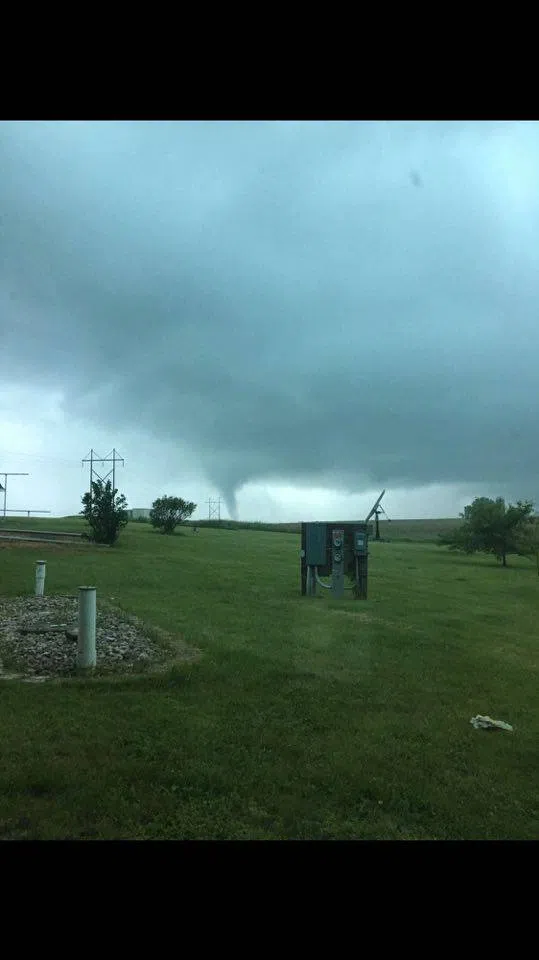
Forecasters warn of isolated to scattered supercell development in north-central and central Wisconsin from mid-afternoon to sunset. If supercells form, they could produce strong tornadoes, very large hail, and damaging winds. However, there remains some uncertainty regarding the extent and timing of this activity.
Evening into Overnight:
Confidence is higher (70-80% chance) that a more organized squall line will sweep across the area between 8 p.m. and 1 a.m. This line of storms could produce embedded tornadoes, widespread damaging winds up to 70 mph, golf ball-sized hail, and pockets of flash flooding. Officials stress that the nighttime timing of the storms could make them more dangerous, as it may limit visibility and response time.
“Today poses a significant severe weather risk for much of the area, especially this evening and overnight,” the NWS emphasized in its early morning update. “Have multiple ways to receive warnings, including weather apps, NOAA Weather Radio, and alert systems.”
Key Hazards:
- Tornadoes: Strong tornadoes possible.
- Large Hail: Up to golf ball size, capable of damaging vehicles, homes, crops, and posing risks to those outdoors.
- Damaging Winds: Gusts up to 70 mph, potentially causing tree damage, power outages, and minor structural damage.
- Localized Flooding: Heavy rainfall could lead to ponding on roads and minor flooding in low-lying areas.
Precautionary Steps:
Residents are encouraged to review their severe weather plans, ensure mobile devices are fully charged, secure outdoor items, and stay tuned for updates as conditions evolve throughout the day.
The National Weather Service will continue to monitor the situation closely and provide updated forecasts and warnings as needed.


Comments